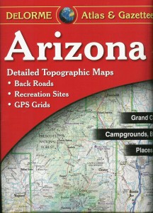
DeLorme topo maps: Essential for the outdoor traveler.
 Since posting my article on dispersed camping a few days ago I’ve had quite a few questions on HOW one goes about finding places to camp on public land. Today I’m prepared to answer that question in the form of a gushing review of the DeLorme’s Atlas and Gazetteer series.
I’ll admit, when I started my review of these priceless books-of-maps, I couldn’t figure out why they went to the trouble of calling them “Atlas and Gazetteers”. So fancy-schmancy… what was the point? Being ever the resourceful one, I decided to find the answer. I called Olivia.
“I dunno” she informed me. “Look it up.”
So I did.
Atlas: /’atles/ A book of maps or charts.
Gazetteer: /gazi’ti(Ə)r/ A geographical directory of places containing information on things like mountains, waterways, camping areas, historic markers, state and national parks, roads etc.
Huh.
Put them together and that’s exactly what we have here: A book of amazingly detailed, large-format topographic and informative maps.
Because Atlas and Gazetteer is too long to keep saying I will here-to-fore refer to these publications as A&G.
I’ve been a fan of this A&G series for a very very (very) long time. It’s amazing how often we use these them. They go everywhere with us, they even have a permanent spot in the back of the van underneath the mat so that if we’re out of the house, so are they.
They provide information on camping, hiking trails, cities, and most importantly, back roads! And they have a version for all 50 states.
How do I use them? Well, let’s take some hypothetical situations that (strangely) mirror real ones that may or may not actually happen on a regular basis. Here is a small portion from this sample page. (note the A, B, C correlations to the map). (more…)
 The folks at Chaco were nice enough to hook up a few of my favorite outdoor kids with a pair of Chacos last spring. After putting their shoes to work all summer these kids are ready to talk about how THEY view their new footwear.


 I got an iphone just before Christmas. I love it… mostly because it works all the time. But as an added bonus, it turns out iphones are like swiss army knives where you get to choose the tools and gadgets it has. (Bejeweled, anyone?) I’ve been looking at outdoor apps a lot (I got an app store gift certificate for Valentine’s Day) and thought I’d share with you the myriad choices available to the nature-lover… I’ve included both those useful to the iphone-folk as well as the droid-folk. Of course, I put several under each numeral; these apps achieve the same end-goal, but go about it slightly differently. I’m all about providing options!


 How many of you are familiar with this scenario: